
The Greenland Ice Sheet (GrIS) is the largest single contributor to global-mass-induced sea-level rise. However, the processes of englacial meltwater accumulation, storage and ultimate release remain poorly constrained. Ran et al (2018) showed that temporal meltwater accumulation and release in Greenland can be sensed by GRACE satellite gravimetry data. Unfortunately, a poor spatial resolution of those data does not allow one to see details of that process. To that end, Ran et al (2024) proposed to analyze bedrock elastic deformation measured by GPS stations at the Greenland coast. They showed that a noticeable amount of the summertime meltwater is temporally buffered along the entire GrIS periphery and, for the first time, quantified the associated water storage times. They also showed that the meltwater runoff modelled from regional climate models may contain systematic errors, up to 20% for the warmest years. These results reveal a high potential for GPS data to constrain poorly known hydrological processes in Greenland, forming the basis for improved projections of future GrIS melt behavior and the associated sea-level rise.
Jiangjun Ran (Department of Earth and Space Sciences, Southern University of Science and Technology, Shenzhen, China), Pavel Ditmar (Department of Geoscience and Remote Sensing, Delft University of Technology, Delft, The Netherlands), Michiel R. van den Broeke (Institute for Marine and Atmospheric Research, Utrecht University, Utrecht, The Netherlands), and Shfaqat Abbas Khan (Department of Geodesy and Earth Observation, DTU Space—National Space Institute, Technical University of Denmark, Kongens Lyngby, Denmark)
Buffered water storage in Greenland
Increased meltwater runoff constitutes the largest contributor (roughly 55%) to post-2000 ice mass loss in Greenland. En route to the ocean, meltwater may be temporarily stored in various hydrological compartments, including surface lakes, firn (the layer of compressed snow that covers ~90% of the ice sheet), as well as ice cavities inside and at the bottom of the ice sheet. Most of this Buffered Water Storage (BWS) is gradually released to the ocean before the onset of the next melt season. BWS affects ice-sheet evolution in several ways. In the interior accumulation zone, water typically percolates into the firn layer, in which it refreezes or recharges firn aquifers. When melt increases, the firn is subject to “degradation”, so that its capacity to store water is reduced, and the contribution of the ice sheet to sea level rise increases. In the marginal ablation zone, meltwater drains to the ice sheet–bedrock interface through moulins and crevasses, inducing high basal water pressure. This creates a temporary lubrication effect and ice-flow acceleration, particularly at the beginning of the melt season. Unfortunately, details of the meltwater transportation towards the ocean remain poorly known. Ran et al (2018) have demonstrated that the BWS in Greenland can be detected by satellite gravimetry data delivered by the GRACE mission. However, an insufficient spatial resolution and accuracy of those data hardly allow the process of water transportation to be further quantified.
Elastic deformations of the bedrock based on GPS data and a comparison with GRACE data
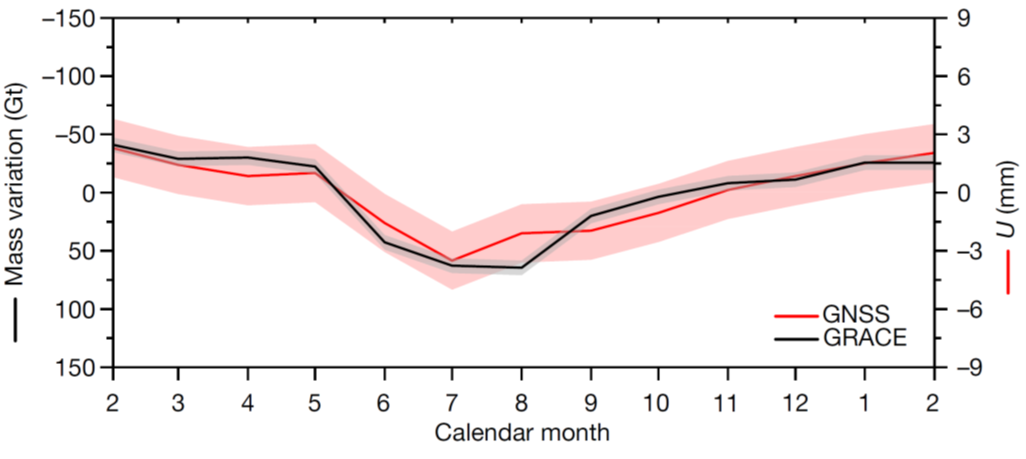
Ran et al (2024) proposed a new method to quantify the spatiotemporal evolution of Greenland BWS: by dedicated analysis of continuously monitored elastic bedrock deformation at 22 Greenland GPS Network (GNET) stations distributed along the coast. Elastic bedrock deformation occurs instantaneously when mass is redistributed. The accumulation of mass at the surface leads to crustal subsidence, whereas mass removal causes crustal uplift. When the raw GPS data are corrected for known (modelled) nuisance signals, one obtains time series of residual vertical displacements of the bedrock. The corrections concern, among other, the glacier Surface Mass Balance (SMB), representing the seasonal accumulation and ablation of snow and ice. Importantly, today's SMB models only account for local, shallow meltwater storage; lateral meltwater transportation is still beyond their scope (i.e., runoff is assumed to reach the ocean instantly). The results based on elastic loading data from GNET were validated through a comparison with water mass changes extracted from GRACE satellite gravimetry data, corrected for nuisance signals consistently with the GPS data. When averaged over entire Greenland (Fig. 1), the comparison demonstrates that the observed signals are rather similar, implying that they are real and not artefacts caused by data errors.
Water storage time
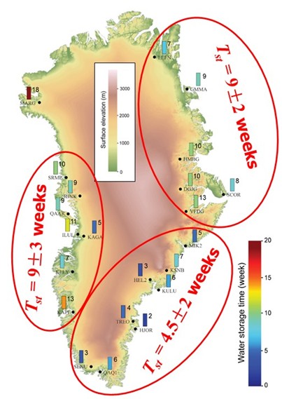
Analysis of residual vertical displacements of Greenland bedrock in 2009–2015 allowed Ran at al. (2024) to quantify, among other, the average water storage time (i.e. the time it take water to reach the ocean) in different parts of Greenland, see Fig. 2. It is found that this time is typically in the order of 9 weeks. An exception is the southeast coast, where this time is halved, which is partly explained by the steep topography and relatively short distance from surface melt locations to the ocean.
Scaling of the modelled runoff
Another finding based on the residual vertical displacements is that the meltwater runoff may be systematically over- or under-estimated by regional climate models. In warm summers, such as those in 2010 and 2012, the modelled runoff must be upscaled, in average, by 20%, to bring it agreement with the observations. This is evidence of the adopted model either underestimating melting or overestimating water retention in ‘warm’ years (or both). The latter might be explained by too weak modelled firn degradation in ‘warmer’ years. Thus, an adjustment of current models for what are currently considered to be warm summers is needed. This is particularly relevant in view of projected Arctic warming. What are considered extremely high summer temperatures today may become normal in the foreseeable future. Thus, good model performance for warmer years is critical to project ice-sheet melting behaviour and associated sea-level rise in the coming decades.
Further Reading
- Jiangjun Ran, M. Vizcaino, P. Ditmar, M.R. van den Broeke, T. Moon, Ch.R. Steger, E.M. Enderlin, B. Wouters, B. Noël, C.H. Reijmer, R. Klees, M. Zhong, L. Liu, and X. Fettweis, 2018. Seasonal mass variations show timing and magnitude of meltwater storage in the Greenland Ice Sheet. The CryosphereThe cryosphere is all parts of a climate system that are covered with ice. The Earth's cryosphere includes glaciers, polar ice, ice sheets, sea ice and snow. The cryosphere is an important indicator of climate change and contributes significantly to ..., 12, pp. 2981–2999.
- Jiangjun Ran, Pavel Ditmar, Michiel R. van den Broeke, Lin Liu, Roland Klees, Shfaqat Abbas Khan, Twila Moon, Jiancheng Li, Michael Bevis, Min Zhong, Xavier Fettweis, Junguo Liu, Brice Noël, C. K. Shum, Jianli Chen, Liming Jiang, and Tonie van Dam, 2024. Vertical bedrock shifts reveal summer water storage in Greenland ice sheet. Nature, 635, pp. 108–113. doi.org/10.1038/s41586-024-08096-3.