How much water can a watershed still release even without rain? To address this, the term Total Drainable Water Storage (TDWS) has been introduced: It refers to the water stored in soil, groundwater, and snow that slowly flows into rivers, bridges dry periods, and protects ecosystems. Since the GRACE satellites measure water storage but cannot specify which water actively contributes to runoff, models are used to link storage capacity and river discharge. By linking a land storage model with a river system model, the discharge at the outlet of a watershed can be represented as a function of changes in storage. Globally, the TDWS concept is applied to various river basins and represented as equivalent water height (EWH) to illustrate the spatial distribution of the storable freshwater volume. The distribution varies depending on climate, soil properties, and landscape.
Alireza Sobouti, Mohammad Tourian und Nicolaas Sneeuw, University of Stuttgart
How much water can a basin release if it does not rain?
Imagine a world where no rain falls, days stretch into weeks, weeks into months; how much water, then, can still drain from a river basin? In such a scenario, the river would continue to flow for a while, sustained by hidden reserves stored in soils, groundwater, and snow.
This slow and quiet release is what keeps rivers alive beyond the rain, supporting ecosystems and buffering dry periods. It is this drainable portion of stored water that we call Total Drainable Water Storage (TDWS), the water that can gradually empty from a basin and sustain flow long after precipitation has ceased.
We can see water from space
While space missions such as GRACE and GRACE-FO have revolutionized our ability to observe total water storage variations from space, they cannot directly determine how much of that water is actively coupled to the drainage system. They measure all changes in water mass regardless of whether that water is locked in soils, stored underground, or actively contributing to river flow. As a result, an important question remains: how much of the observed water is truly available to sustain rivers over time? Answering this requires going beyond observations alone.
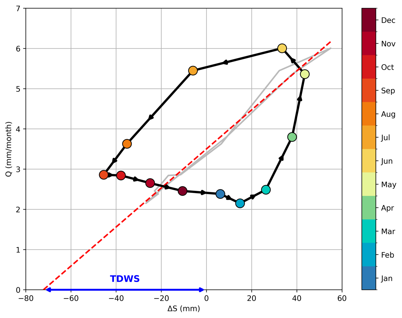
Linking water storage to river flow
© Sobouti, Tourian, and Sneeuw
To understand how much stored water can sustain rivers, it is necessary to connect water storage on land with the flow of water through rivers. The ESA Earth System Model describes how water is stored across the land and how it changes over time. In parallel, the LISFLOOD model simulates the distribution and movement of water in a river system, allowing us to obtain river discharge from the outlet of a basin. The connection between water storage anomaly and river discharge is based on a simple idea: the amount of water flowing out of a basin is proportional to changes in water storage.
This relationship can be visualized by comparing water storage anomalies with river discharge over time using long-term monthly averages (see Figure 1). When discharge is plotted against storage anomalies, the points do not fall on a single line but form a loop, reflecting the delayed response of runoff to changes in storage. After accounting for this time lag, the relationship becomes clearer and almost linear. Each point in the figure shows how much water is stored in the basin and how much flows out as discharge. As expected, higher storage leads to higher discharge. Extending this relationship towards lower storage values reveals the point where discharge becomes zero, meaning the basin can no longer sustain river flow. The position of this point indicates how much water can flow out of the basin before discharge stops. We define this as the TDWS.
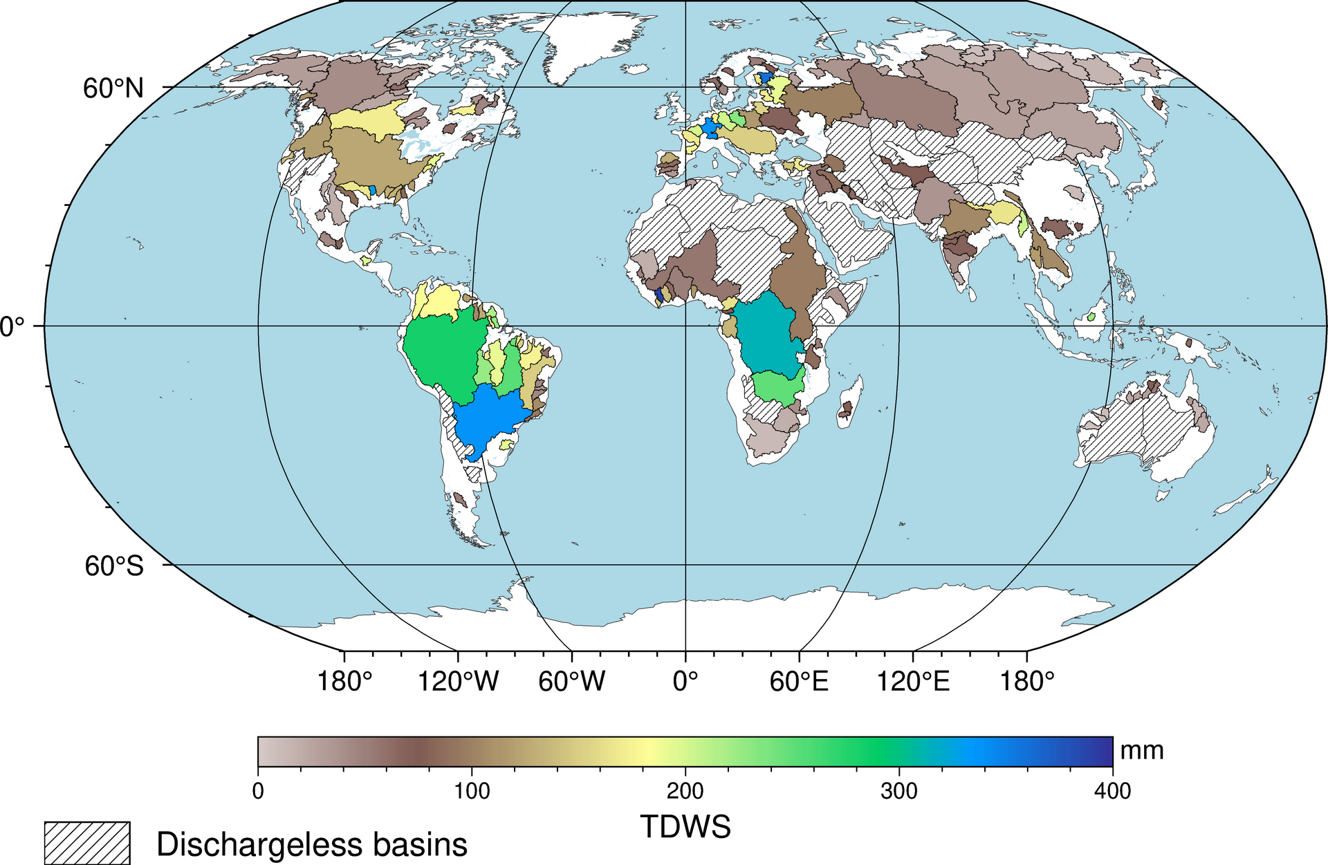
A global picture of TDWS
© Sobouti, Tourian, and Sneeuw
We now extend this analysis to the global scale using the ESA Earth System Model. By applying the same approach across different river basins, we estimate the global distribution of Total Drainable Water Storage (TDWS), represented in terms of equivalent water height (EWH). In this form, TDWS provides a useful proxy for the spatial distribution of total freshwater resources. The results show that TDWS is not uniform across the Earth, but varies between climate zones and regions. This variability highlights the influence of hydroclimatic conditions, soil properties, and landscape characteristics on how water is stored and released.
Further Reading
- Tourian, M. J., Papa, F., Elmi, O., Sneeuw, N., Kitambo, B., Tshimanga, R. M., ... & Calmant, S. (2023). Current availability and distribution of Congo Basin’s freshwater resources. Communications Earth & Environment, 4(1), 174.
- Tourian, M. J., J. T. Reager, and N. Sneeuw. “The total drainable water storage of the Amazon river basin: A first estimate using GRACE.” Water Resources Research 54.5 (2018): 3290-3312.
- Dobslaw, H., Bergmann-Wolf, I., Dill, R., Forootan, E., Klemann, V., Kusche, J., & Sasgen, I. (2015). The updated ESA Earth System Model for future gravity mission simulation studies. Journal of Geodesy, 89(5), 505-513.
- Riegger, J., & Tourian, M. J. (2014). Characterization of runoff‐storage relationships by satellite gravimetry and remote sensing. Water Resources Research, 50(4), 3444-3466.