A new satellite-based evapotranspiration product reveals water-use patterns in the Ganges Basin that conventional approaches can miss. By combining precipitation, runoff, and terrestrial water storage as observed by GRACE/-FO, the method captures the influence of groundwater-fed irrigation on evapotranspiration.
Shubham Goswami, Chirag Rajendra Ternikar und Bramha Dutt Vishwakarma, alle Indian Institute of Science, Bangalore, Indien
Measuring evapotranspiration in an intensively irrigated basin
Evapotranspiration (ET)—the combined loss of water through evaporation and plant transpiration—is a key component of the terrestrial water cycle. Estimating ET, however, remains challenging, particularly in regions where human water use strongly modifies natural hydrological processes.
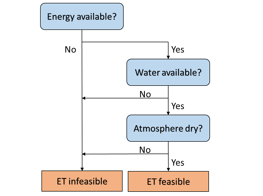
ET requires three basic conditions: sufficient energy, available water and an atmosphere capable of accepting additional moisture (Figure 1). Many satellite-based ET products estimate these conditions using vegetation indices, land-surface temperature and meteorological observations. In intensively irrigated regions, however, vegetation development does not necessarily reflect how much water is available at the surface. Groundwater pumping, for example, can supply large quantities of water even during dry periods.
Using GRACE to close the water balance
Goswami et al. (2024) developed a global ET product with a new approach that utilizes the terrestrial water balance:
ET = precipitation − runoff − change in water storage.
The method combines satellite-based precipitation and runoff data with changes in terrestrial water storage (TWS) as observed by the GRACE satellite missions. A Kalman filter was used to merge 96 combinations of input datasets into a single ET estimate (KF-ET). The product was subsequently evaluated against eddy-covariance observations, hydrological model simulations, and previously existing ET products.
The inclusion of GRACE-derived storage changes is particularly useful because GRACE observes changes in the total amount of water stored above and below the land surface, including groundwater. This provides an opportunity to capture water-use dynamics that may be difficult to identify from vegetation or surface conditions alone.
Revealing irrigation-driven water use in the Ganges Basin
The Ganges Basin is home to nearly 500 million people and contains some of the world's most intensively irrigated agricultural areas. Groundwater plays an important role in supporting agriculture, including the widespread irrigation of rice fields.
The GRACE-based ET product reveals an interesting feature during months that are not characterized by strong precipiation associated with the Monsoon: ET remains high and shows a pronounced peak in June, despite low rainfall and relatively sparse vegetation (Figure 2). This coincides with the onset of groundwater-fed irrigation, when fields are flooded in preparation for rice cultivation.
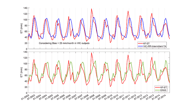
Atmospheric conditions in June also favour evaporation. Net radiation is relatively high and humidity is lower than during the subsequent monsoon months. Irrigation therefore provides the necessary water at a time when sufficient energy and atmospheric demand are also present. This ET peak in June is clearly captured by the GRACE-based KF-ET product, but is missed out entirely by several products that depend more strongly on vegetation dynamics.
From water storage to water use
These results demonstrate an important application of satellite gravimetry. GRACE does not observe evapotranspiration or groundwater pumping directly. Instead, it measures changes in Earth's gravity field caused by changes in water storage. When these observations are incorporated into the water balance equation, they provide information on how changes in stored water are connected to water use.
This is particularly relevant in the Ganges Basin, where groundwater can both sustain river flow and supply irrigation water that subsequently returns to the atmosphere through ET. Independent isotope-based observations also highlight this strong interaction between groundwater, river flow, and evaporation in the basin.
The current ET product has limitations, particularly its monthly temporal resolution and relatively coarse spatial resolution. Future satellite-gravimetry missions such as NGGM/MAGIC from ESA (to be launched in 2032) will help improve the observation of water-storage changes, while combining water- and energy-balance approaches may provide more detailed ET estimates.
But already now, the study shows how GRACE observations can help uncover human influences on the water cycle that are difficult to detect from surface observations alone. In heavily irrigated basins such as the Ganges, changes in water storage can provide an important window into when and how groundwater is being used.
References
- Goswami, S. et al. (2024). Water budget-based evapotranspiration product captures natural and human-caused variability. Environmental Research Letters, 19, 094034.
- Joseph, J. et al. (2022). Is flood to drip irrigation a solution to groundwater depletion in the Indo-Gangetic plain? Environmental Research Letters, 17(10), 104002.
- Laskar, A.H. et al. (2025). Hydrological Dynamics in Giant Tropical Rivers: A Case Study of the Ganga River. Hydrological Processes, 39(7), e70187.
- Fisher, J.B. et al. (2017). The future of evapotranspiration: Global requirements for ecosystem functioning, carbon and climate feedbacks, agricultural management, and water resources. Water Resources Research, 53(4), 2618–2626.
- Daras, I. et al. (2024). Mass-change And Geosciences International Constellation (MAGIC) expected impact on science and applications. Geophysical Journal International, 236(3), 1288–1308.