Gravimetric Earth observation is a crucial approach to understanding the causes of climate change and providing accurate predictions of its consequences for nature and society. The spatial and temporal variations of the gravitational field provide unique information about the relevant change processes in the Earth system - from the atmosphere to below the Earth's surface. Current gravity field data is however severely limited in its temporal and spatial resolution. Innovative quantum technologies have the potential to provide data with significantly higher accuracy and long-term stability in the future. The collaborative research center (CRC) 1464 "Relativistic and Quantum-based Geodesy" has been established for this purpose.
Text: Dr. Matthias Weigelt, Leibniz Universität Hannover
TerraQ is a joint project and funded by the German Research Foundation. The project partners are Gottfried Wilhelm Leibniz Universität Hannover, the Physikalisch-Technische Bundesanstalt, the Centre of Applied Space Technology and Microgravity, the German Aerospace Centre, the Helmholtz Centre Potsdam German Research Centre for Geosciences, HafenCity University Hamburg and Graz University of Technology.
At the core of the TerraQ CRC is a unique interdisciplinary collaboration between scientists from the fields of geodesy and quantum physics. By combining expertise from engineering and basic research, we aim to improve the spatial and temporal accuracy of geodetic observations of mass variations to a new level. Our goal is to advance quantum-based measurement concepts for the monitoring of mass variations from space and on the ground. The corresponding data analysis and modelling provides sophisticated methods that significantly expand our knowledge of the associated change processes in the Earth system.
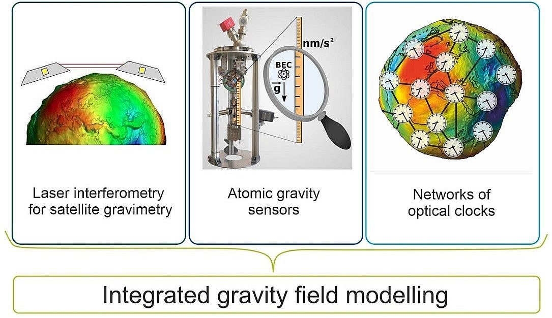
In the field of satellite gravimetry, the changing distance between two satellites orbiting the Earth can be precisely measured allowing to derive the exerted gravitational force. TerraQ researchers have already been involved in previous successful satellite missions such as GRACE-FO. The CRC is now developing laser-based systems that will enable the next step in distance measurements in terms of spatiotemporal resolution and accuracy, i.e., the realization of the nanometer level.
Based on matter wave interferometry with cold atoms, terrestrial quantum sensors for fast and highly accurate gravity measurements are being developed to achieve an accuracy level of a few nm/s². These developments include both compact, mobile devices for field campaigns and large stationary devices with extreme precision. While the former enables new strategies for local and regional gravity measurements, the latter will provide a new gravity standard in the future.
TerraQ is a leader in the development and establishment of chronometric levelling for the realization of physical height systems and for gravity field investigations. The decisive factor here is the determination of frequency differences due to gravitational redshift between distant clocks in order to record gravitational potential differences in geodetic networks. For this purpose, optical atomic clocks are connected to each other via fiber optic cables. These clocks and concepts are initially being developed with an accuracy in the centimeter range; later, the accuracy required for geodetic applications is to be achieved at the millimeter level.
Technology development in the field of satellite gravimetry
Novel and high-precision sensor systems are built on the legacy of the LISA Pathfinder Mission (LPF) and GRACE-FO. We are investigating new concepts for optical accelerometers and extending them to gradiometers. Mission concepts for these new payloads are being investigated. The focus here is on multi-sensor systems, considering the measurement geometry and -configurations, the measurement platforms, their environment, contamination and geophysical signals that influence the measurement process. Multi-purpose space mission simulatorsNew types of satellite missions are regularly developed with the help of purely virtual and highly modularised test environments. Taking detailed satellite models into account, a wide range of interactions between various sensors, satellite systems a... provide the necessary simulations of spacecraft and optical systems. An important aspect of this is the improvement of beam characterization methods. Unavoidable beam imperfections and differences in the detailed signal definition influence the interferometric performance and thus the accuracy of the gravity field determination.
The potential of the auxiliary modulations on the laser link derived from the Laser Interferometer Space Antenna (LISA) mission will also be exploited. Furthermore, the necessary optical readout procedures for test masses to improve future accelerometers will be developed experimentally. New and compact sensors utilize newly discovered modulation techniques such as deep phase modulation or deep frequency modulation. A key component of this is the torsion balance, a particularly low-noise test platform. While test masses that are completely free-floating on long time scales are not feasible on the ground, significant tests can be carried out in one or two degrees of freedom in a torsion balance, thus enabling research to stabilize the apparatus and read out the relevant signals.
Contributions to gravity field determination
The combined use of clocks, atomic and laser interferometry, ground-based or from space, is essential to provide data on all length and time scales. The research areas are closely interwoven and thus lead to a new level of accuracy in the observation and knowledge of the gravitational field. We model gravitational field quantities both classically geodetically and relativistically and simulate relevant application scenarios demonstrating the performance of the newly developed measurement concepts in comparison to existing approaches.
Observations of the temporal variations of the Earth's gravity field by means of satellite gravimetry, terrestrial gravimetry and by uplift effects measured with Global Navigation Satellite Systems (GNSS)Generic term for a class of satellite positioning systems that are operated by different countries or groups of countries. These include GPS of the USA, Galileo of the European Union, the Russian system GLONASS, the Chinese solution BEIDOU, as well a... allow an insight into the regional variations and changes of water reservoirs on different spatial and temporal scales. The uniform integration of the different geodetic sensors is one of the greatest challenges in geodesy due to the different spatial and temporal sensitivity of the measurement systems. In addition to using observations from the GRACE or GRACE-FO satellite system and GNSS deformation time series, we also utilize terrestrial absolute and relative gravimeters of various types. The planned use of absolute quantum gravimeters is particularly noteworthy. This will lay the foundation for the next generation of gravimetric measurement networks.
By integrating expertise from geodesy and physics, TerraQ serves as a unique platform for the development of fundamentally new sensors and measurement methods based on quantum metrology, synergistically combining technological development and the requirements of space missions with geodetic and geophysical modelling.
Further information
- Homepage of the Collaborative Research Center TerraQ https://www.terraq.uni-hannover.de/en/
- GRACE Follow-On am Max-Planck-Institut für Gravitationsphysik https://www.aei.mpg.de/gracefo
- LISA Pathfinder https://www.aei.mpg.de/344455/lisa-pathfinder
- TerraQ is part of the cluster of excellence QuantumFrontiers EXC 2123 https://www.quantumfrontiers.de/en/